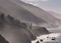
It might be the most dramatic drive in the Lower 48. It stretches across 90 miles of jagged cliffs and scenic vistas, and it reveals more twists and turns than the latest Dan Brown bestseller. “It” is Big Sur, California’s rugged “Big South,” and the famous white-knuckle drive along Highway 1 is only part of the story.
The backcountry
On my recent trip, I set out to explore the best of both worlds: the rocky coast and breezy beaches of Highway 1, and the rugged mountains of Big Sur’s backcountry. A trip like this can be done in about three or four days without feeling rushed, even for travelers who–like me–fly in from the East Coast. In my case, I arrived in San Francisco by mid-afternoon and ended the first day of my visit in Pfeiffer Big Sur State Park, about a three-hour drive south of the Bay Area.
Flanked by the Santa Lucia Mountains to the east and the Pacific Ocean to the west, Pfeiffer Big Sur is home to family-friendly day hikes such as the Pfeiffer Falls loop (to a 60-foot waterfall and back), the Valley View trail (through a misty redwood grove), and a moderate climb to Buzzard’s Roost (with ridgeline views that stretch back to the ocean). I was able to do all three trails before lunch on my first full day. I saw college students, families with young children, and seniors in their 60s on the Valley View and Pfeiffer Falls trails. On the more challenging Buzzard’s Roost Trail, I had the panoramic views all to myself.
Big Sur’s real backcountry, though, is the Ventana Wilderness. Ventana is a 167,000-acre stretch within Los Padres National Forest where mountain lions roam the Santa Lucia Mountains, which rise nearly a mile into the sky. This is the Big Sur that few people ever see, and while it’s not to be taken lightly, it is ripe for active travelers to explore.
For a revealing view of the Ventana Wilderness, physically fit hikers should save a full day for the 10.8-mile round-trip Manuel Peak Trail. The trailhead starts inside Pfeiffer Big Sur and is well worth the hike, but don’t attempt it without plenty of water, good hiking boots, and proper preparation. You’ll need more than the four days I had to explore the rest of the backcountry, but if you choose to do so, several of the campers I spoke with recommended the Pine Ridge Trail to Sykes Hot Springs, about 23 miles into the wilderness.
The coastal route
Highway 1 is dotted with campgrounds and rustic cabins. Some are affordable (as low as $25 for a campsite in Pfeiffer Big Sur), some are reasonable ($74 for a TV-free room with a hot shower at the Glen Oaks Motel just outside Pfeiffer Big Sur), and some are ridiculous (upwards of $1,000 a night for the best rooms at the Post Ranch Inn). In all cases, reservations are recommended in the summer, although I had no difficulty finding accommodations on short notice when I traveled in early April.
Save time to stop for lunch or dinner (or, for a real treat, rent a cabin) at the Lucia Lodge, which teeters on the edge of a cliff about 25 miles south of Pfeiffer Big Sur. The above-average Americana fare (big hamburgers and cold beer) is complemented by the ocean views from the deck and picnic area.
Dinner at The Big Sur Roadhouse (across from the Glen Oaks motel) is pricey but surprisingly sophisticated considering its remote location and laidback atmosphere. The Ripplewood Cafe, close to several campgrounds, is good for breakfast (buttermilk pancakes, omelettes any style) and better for people-watching. It’s frequented by hikers and campers trudging over from the nearby Ripplewood Cabins before setting off for the day’s adventure.
Because of its proximity to the Santa Lucia range, there are limited radio and cell phone signals all along Highway 1. But who needs them? Slow down, listen to the surf, and taste the ocean air as you drive. While the entire coastline is frequently shrouded in fog as a result of the areas’s unique environment, it’s these same conditions that give life to the coastal redwoods, found only in two other places in the world. The fog doesn’t ruin the experience; it’s part of it.
Getting there
Big Sur encompasses a large stretch of California’s central coast. The best advice for saving money on transportation is to research fares from your city to the different California airports: San Francisco, Oakland, or San Jose in the north; Los Angeles and the surrounding cities in the south. I saved almost $200 by choosing the Bay Area over Los Angeles.
Whatever your interests, your visit to Big Sur will benefit from Wilderness Press’ just-published Hiking & Backpacking Big Sur. This invaluable guide by Analise Elliott was a welcome companion on my trip and provided helpful tips, accurate trail descriptions, and interesting reading about the geographical and natural history of the area. For the drive along Highway 1, I also found Lonely Planet’s Coastal California a good–if frequently too brief–starting point for my trip.
We hand-pick everything we recommend and select items through testing and reviews. Some products are sent to us free of charge with no incentive to offer a favorable review. We offer our unbiased opinions and do not accept compensation to review products. All items are in stock and prices are accurate at the time of publication. If you buy something through our links, we may earn a commission.
Related
Top Fares From
Today's Top Travel Deals
Brought to you by ShermansTravel
Shop and Save with Country Inns...
Patricia Magaña
 Hotel & Lodging Deals
$229 -- Chicago: Discounted Rates and...
Francesca Miele
 Hotel & Lodging Deals
$229+
$188 -- Honolulu: Save on Oceanview...
Abigail Lamay
 Hotel & Lodging Deals
$188+


